In early 1488, a Portuguese navigator named Bartolomeu Dias became the first European mariner ever to round the southern tip of Africa. He did it without even knowing it had happened.
Driven off the African coast by fierce storms, his small fleet sailed south and then east through open ocean for thirty days before finally turning north and finding land. When they did, the coast was running northeast. Africa’s great southern barrier was behind them. The Atlantic and the Indian oceans had connected.
That moment — somewhere in the churning waters off what is now South Africa — changed the world. It opened the sea route between Europe and Asia, ended a century of Portuguese effort, and set the stage for Vasco da Gama’s voyage to India just a decade later. The entire modern global trading system has roots in what Dias accomplished during those sixteen months at sea.
Why Portugal Was Searching for a Route Around Africa in the First Place
To understand what made Dias’s voyage so extraordinary, it helps to understand the problem it was designed to solve.
For centuries, the spice trade between Europe and Asia had flowed through a chain of overland routes—what we now call the Silk Road—passing through the Middle East, through Arab and Venetian merchants who controlled the flow of goods and extracted enormous profits at every stage. When the Ottoman Empire conquered Constantinople in 1453 and consolidated control over those land routes, the cost of Asian goods in European markets became nearly prohibitive.
There had to be another way. And Portugal, positioned on the southwestern tip of Europe, jutting into the Atlantic, was the nation best placed to find it.
The driving force behind Portugal’s exploration program was Prince Henry, known to history as Henry the Navigator, born in 1394 and died in 1460. At his research center at Sagres in southern Portugal, Henry assembled the finest cartographers, astronomers, and navigators of the age. He compiled geographic knowledge; improved the design of the caravel — the light, maneuverable sailing ship that would define the Age of Exploration — and systematically directed Portuguese expeditions southward along the African coast, beginning around 1418.
Henry did not live to see the great breakthrough. But the program he started continued after his death under the determined patronage of King João II, who ascended to the Portuguese throne in 1481. João was convinced that the sea route to India lay around Africa’s southern tip. He ordered expedition after expedition to push further south, each one planting stone pillars called padrões along the coast to mark Portuguese claims.
The explorer Diogo Cão made two voyages — in 1482 and again in 1485–86 — reaching as far south as Cape Cross in present-day Namibia. But beyond Cão’s last marker, the coast remained unknown to Europeans. João II needed a navigator bold enough to go further than anyone had gone before. He chose Bartolomeu Dias.
Who Was Bartolomeu Dias? The Man King João II Chose for the Mission
Almost nothing is known about Bartolomeu Dias’s early life. He was born around 1450, probably into a family with a seafaring background. His ancestor Dinis Dias had explored the African coast in the 1440s and discovered the Cap-Vert peninsula in what is now Senegal. Bartolomeu himself served at the court of King João II, holding the modest rank of squire of the royal household and serving as superintendent of the royal warehouses.
His sailing experience before 1487 is largely undocumented, but he had almost certainly accumulated extensive time at sea. In 1481, he had accompanied an expedition led by Diogo de Azambuja to construct a Portuguese fortress and trading post at São Jorge da Mina in the Gulf of Guinea. That voyage would have introduced him to the conditions and demands of extended African coastal sailing.
When João II selected Dias to lead the new expedition, he was trusted with the most ambitious mission yet attempted by Portugal: to find the southern end of Africa and prove that a sea route to India was possible.
The Expedition Sets Sail: August 1487 and the Push South
Dias departed from Lisbon in August 1487, commanding a fleet of three vessels. His own flagship was the São Cristóvão. The second caravel, the São Pantaleão, was commanded by João Infante and piloted by Álvaro Martins. The third vessel was a supply ship — a heavier, square-rigged vessel — commanded by Dias’s brother Pêro, whose task was to carry extra provisions and remain anchored in a sheltered bay while the two lighter caravels continued into unknown waters.
Among the leading pilots who sailed with Dias were Pêro de Alenquer and João de Santiago, both veterans of Cão’s earlier voyages and experienced navigators of the African coast. Also aboard were six Africans who had been brought to Portugal by earlier expeditions. They were dressed in European clothing and were to be set ashore at suitable points along the coast to serve as emissaries, carrying gold, silver, and goods to signal Portugal’s peaceful trading intentions to local populations.
The expedition followed the African coast southward through familiar waters. By early December 1487, Dias had passed Cão’s farthest marker and entered truly unknown territory. He reached Walvis Bay on December 8 and continued slowly along the Namibian coastline. At Angra do Salto — likely in modern Angola — he left the supply ship under the guard of nine men and pressed on with only the two caravels. Three of those nine men would be dead by the time Dias returned.
The Great Storm and the Accidental Rounding of Africa
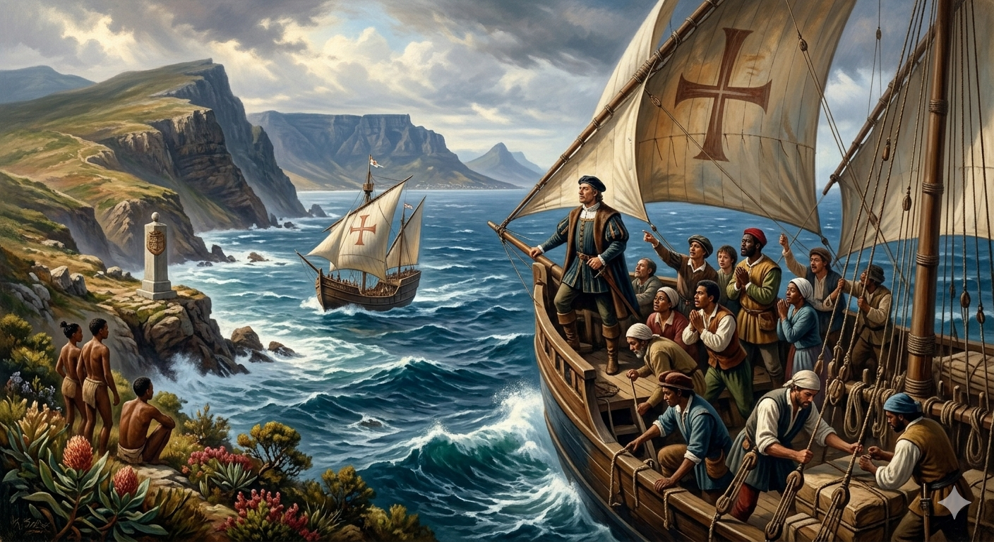
In early January 1488, as Dias’s two caravels sailed off the coast of what is now South Africa, the weather turned catastrophically violent. A storm — some accounts say it lasted thirteen days — drove the ships far out into the open ocean, away from the coast they had been following. The ships had no sight of land.
Dias was now navigating in waters no European had ever charted. There were no maps to consult, no landmarks to identify. When the storm finally eased, he turned east, expecting to find the African coast. No land appeared. He turned north and, on February 3–4, 1488, after approximately thirty days on the open ocean, the two ships made landfall. They were in a bay they named São Bras — present-day Mossel Bay, in what is now South Africa’s Western Cape province.
The waters were warmer. The coast was trending northeast. Without fully grasping it in that moment, Bartolomeu Dias had rounded the southern tip of Africa. The storm that had terrified his crew and driven them off course had unknowingly carried them around the Cape.
When they landed at Mossel Bay, the encounter with the local Khoikhoi people was not peaceful. The indigenous inhabitants pelted Dias’s ships with stones. During the confrontation, Dias or one of his men fired an arrow that struck and killed a Khoikhoi man — the first recorded violent clash between Europeans and the indigenous people of southern Africa.
Sailing East Along the Southern African Coast to the Furthest Point
Dias pressed on eastward. He sailed along what is now the southern coast of South Africa, confirming that the coastline continued to trend northeast — the direction that, if followed far enough, would eventually lead to the Indian subcontinent.
He reached Algoa Bay, near present-day Port Elizabeth. Then he continued to what the Portuguese called the Río do Infante — the Great Fish River, in what is now South Africa’s Eastern Cape province. By this point, the crew was exhausted, frightened, and increasingly insistent on turning back. Supplies were dangerously low. The ships were battered.
The mutiny that threatened never fully erupted, but Dias recognized how close it was. He did what captains in extreme circumstances sometimes do — he formed a council. All the officers were invited to state their views. The verdict was unanimous: they would sail three more days east. Then they would turn for home.
On March 12, 1488, Dias anchored at Kwaaihoek, near the mouth of the Boesmans River — the easternmost point of his entire voyage. There, on a headland, he and his crew erected a stone pillar, the Padrão de São Gregório. This was the marker that would tell the world: beyond this point, no European had gone. The stone cross was recovered, remarkably, from what was later called False Island in 1938, and is now held in a museum in Pretoria.
Dias himself desperately wanted to continue. The Indian Ocean was ahead of him. India was, theoretically, within reach. But he was alone in his desire to press on, and he had no choice but to agree to turn back. He wept, by some accounts, as he ordered the return.
Discovering the Cape on the Return Voyage: May 1488
On the return westward along the coast, Dias finally saw with his own eyes the rocky headland he had blindly rounded during the storm months earlier. It was May 1488.
Standing at the bow and looking at the dramatic rocky promontory where two oceans met, Dias named it Cabo das Tormentas — the Cape of Storms — for the violent weather that had defined his encounter with it. The name was appropriate. The waters around the Cape are among the most treacherous on earth, where the cold Benguela Current from the Atlantic meets the warm Agulhas Current from the Indian Ocean, creating unpredictable storms, powerful swells, and legendary danger for ships.
On June 6, 1488 — Saint Philip’s Day — Dias anchored at the Cape itself and planted a padrão dedicated to Saint Philip on a prominent point. No trace of this cross has ever been found, but a contemporary account from the navigator Duarte Pacheco Pereira records the planting. Pereira was particularly well-placed to know: Dias had rescued him on the return voyage after finding him shipwrecked on the island of Príncipe.
When Dias returned to Angra do Salto to retrieve the supply ship, he found that of the nine men left to guard it, only three had survived. The others had died in attacks by local people. A seventh man died during the voyage home. The expedition limped northward, past the familiar coastlines of West Africa, and finally returned to Lisbon in December 1488, after an absence of sixteen months and seventeen days.
The Naming of the Cape: Who Called It the Cape of Good Hope?
The question of who gave the Cape its famous name has been debated by historians for centuries.
The most popular account, recorded by the 16th-century Portuguese historian João de Barros, says that Dias named it Cabo das Tormentas — Cape of Storms — and that King João II renamed it Cabo da Boa Esperança — Cape of Good Hope — because it symbolized the opening of a viable sea route to India and Asia. “Good hope” referred not to the weather, but to the prospect of commercial and strategic success.
A competing account attributes the name directly to Dias himself. The navigator Duarte Pacheco Pereira, who sailed with Dias and wrote directly from experience, records that Dias himself gave it the name Cabo da Boa Esperança because, on reaching the Cape, he saw that the coast turned northward toward “Ethiopia-under-Egypt and on to the gulf of Arabia, which gave indication and expectation of the discovery of India.” A note in a book owned by Christopher Columbus also records that Dias gave the Cape its optimistic name in his own report to King João.
The truth may never be settled. But the name itself is fitting either way. What Dias had proven was that there was hope — real, navigable, achievable hope — that a ship sailing south from Portugal could round Africa and reach the wealth of Asia.
A Muted Reception and an Unrecognized Achievement
When Dias returned to Lisbon in December 1488, the reception was strangely quiet. There were no official proclamations. No detailed record survives of any audience with King João. No adequate reward for Dias has ever been found in the historical record.
Part of the muted response may have reflected political reality. The Portuguese court was simultaneously hearing reports from Pêro da Covilhã, who had been sent overland to India and was providing crucial navigational intelligence. There was much to process and plan. The news that Africa could be rounded was significant — but it was one piece of a larger puzzle, not yet a completed achievement.
The great Indian expedition was assigned not to Dias, but to Vasco da Gama, who departed in 1497 and reached India in 1498. Dias supervised the construction of two of da Gama’s ships — the São Gabriel and the São Raphael — and accompanied the expedition as far as the Cape Verde Islands before being ordered to a different posting.
In 1500, Dias joined the fleet of Pedro Álvares Cabral, which was sailing toward India along the Atlantic. The fleet swung so far west that it touched the coast of South America — discovering Brazil, which became Portugal’s largest colonial possession. Then the fleet turned east, back toward Africa. As they rounded the Cape of Good Hope on May 29, 1500, a violent storm struck. Four of Cabral’s ships were lost, including Dias’s. Bartolomeu Dias died at sea, in the waters off the Cape that bore his name, at around fifty years of age. The irony is almost too symmetrical to be true: the man who discovered the Cape of Good Hope was killed by it.
The Legacy of Dias: What the Cape of Good Hope Changed Forever
The voyage of Bartolomeu Dias in 1487–1488 was one of the most consequential journeys in the history of human navigation. Its effects rippled across centuries.
Most immediately, it proved what had only been theorized: that the Atlantic and Indian oceans were connected and that ships could sail between them. That knowledge made Vasco da Gama’s 1498 voyage to India possible, which in turn established the first direct maritime trade route between Europe and Asia. The Portuguese commercial empire that followed was one of the first genuinely global economic systems in history.
The route around the Cape of Good Hope remained the dominant channel of communication and trade between Europe and Asia until the opening of the Suez Canal in 1869. For nearly four centuries, every ship carrying spices, silk, porcelain, cotton, and tea between the East and the West rounded the rocky headland that Dias first saw in May 1488.
Dias also made a navigational discovery that would guide generations of sailors after him. He demonstrated that the most effective southward route for ships was not to hug the African coast — where contrary winds and currents fought the ships — but to swing far out into the open Atlantic, using the westerly winds of the Southern Ocean to carry ships around Africa’s tip. That technique, which he either discovered by accident in the storm or by deliberate seamanship, became standard practice for every European vessel bound for Asia for the next three centuries.
His achievement was recognized, belatedly and partially, in his own time. When Vasco da Gama returned from India in 1499, the world understood what Dias had opened. And when Christopher Columbus — who had heard Dias’s report to King João firsthand — failed to find a western route to Asia and instead encountered the Americas, the Portuguese path around Africa became even more important.
Today, the Padrão de São Gregório, or Dias Cross, stands as a memorial at Kwaaihoek. The Discoveries Monument in Lisbon honors Dias alongside the other great navigators of the Age of Exploration. The Cape of Good Hope itself, now part of Table Mountain National Park in South Africa, draws millions of visitors each year who stand on the rocky headland and look out at the churning waters where two oceans meet — the same waters that Bartolomeu Dias first entered from the Atlantic in the winter of 1488.